
This report details a framework established by the United States Department of Interior (DOI) to evaluate the success of 162 of its resilience-focused projects. Building on a previous report that developed performance metrics to measure changes in ecological resilience resulting from the projects, this report focuses on the incorporation of metrics to address socio-economic impacts resulting from the DOI-sponsored projects. These metrics will be used to evaluate projects both individually and across larger scales, with the aim to inform best practices, address knowledge gaps, sustain and enhance improvements in coastal resilience, and further community competence and empowerment.
This report represents the first phase of the Department of the Interior (DOI) assessment effort for Hurricane Sandy projects. It was developed for DOI by a metrics expert group of physical and ecological scientists and socioeconomic experts who recommended performance metrics for measuring changes in resilience resulting from the DOI-sponsored projects. It identifies natural and artificial coastal features most affected by Hurricane Sandy along the northeast coast, including marshes, beaches, and estuaries, and recommends metrics that would indicate resilience changes in those features.
This study examines the relationships among attitudes to climate change, risk perceptions, and coping behavioral intentions in different townships of Yunlin County in Taiwan, which has relatively high vulnerability to the consequences of climate change.
This case study calculates a hazard index for every square kilometer of the United States coastline using five sea-level-rise scenarios. This index is then used to identify the most vulnerable people and property as indicated by being in the upper quartile of hazard for the nation’s coastline. The study delivers the first national map of risk reduction owing to natural habitats and thus indicates where conservation and restoration of reefs and vegetation have the greatest potential to protect coastal communities.
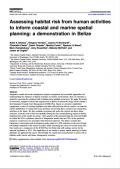
This study introduces an approach for assessing the combined risk to marine habitats from multiple human activities, and applies it to coral reefs, mangrove forests, and seagrass beds in Belize to inform the design of the country’s first Integrated Coastal Zone Management (ICZM) Plan.
This case study applies a contingent valuation approach to estimate how households value different multi-purpose infrastructure (grey or green) for managing flood risk and water pollution. It considers the case of the Gorla water park located north of Milan, in the Lombardy Region of Italy.
This study, conducted in Southern Punjab province, explores the impacts of a massive flood in 2010 on the livelihoods and food security of rural communities. The study found that agriculture was the major income source of the area and that the flood severely affected natural capital (land, irrigation, orchards, and livestock). This resulted in food insecurity, deficiency, and contaminated commodities.
This paper aims to identify the costs of coastal disasters in relation to human, social, built, and natural capital as well as their associated services at the local site of the disaster and in the regions and nations that respond for relief and recovery. It examines how, compared to typical cost accounting, disaster planning and preparedness becomes more cost effective when the full cost of disasters is calculated. A full-cost accounting also sets the stage for rigorous comparisons of strategies for post-disaster development.

This case study evaluates the current and potential social and economic value of Virunga National Park, which is located in the eastern part of the Democratic Republic of the Congo (DRC).
The publication Climate Smart Agriculture: Successes from Africa