Hundreds, if not thousands, of infrastructure projects are being planned and implemented around the world. Their outcomes on society, the economy and the environment are often analyzed, although primarily with a silo approach. This is done to assess whether the project will lead to the desired outcomes, whatever these may be. On the other hand, what are the consequences of reaching those desired goals? How would land use change if the economy develops as desired? What would be the consequences on ecosystem services, and how large would the resulting cost implications be? How would the economy (all actors, including the poor) be impacted by these extra, unexpected costs? The questions of how to overcome this silo and generate information that can effectively support policy makers have so far received little attention.
Many existing and newly developed tools are being put forward to inform decision-making by estimating the short, medium and longer-term outcomes of investments across social, economic and environmental dimensions. But somehow the useful results being produced by these tools are, well, not all that useful for the end-users they are designed to support in the first place. WWF and KnowlEdge Srl (KE) have partnered to review existing methodologies and models and craft an approach that merges existing knowledge to understand if there is a way to make use of the strengths of each tool in an integrated way.
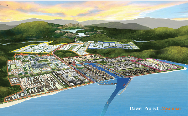
This approach was applied to the “Road to Dawei” project, connecting Bangkok in Thailand to Dawei in Myanmar. During a special meeting of ASEAN Foreign Ministers held in Singapore on May 19, 2008, the foreign ministers of Thailand and Myanmar signed a memorandum of understanding (MoU) on the development of the Dawei deep-sea port project. The project, which involves the construction of a road link from Dawei to Bangkok, can be considered part of an economic development strategy that will increase trade by providing better (faster and cheaper) access to markets. On the other hand, concerns have emerged about the likely impacts of road construction on land use, ecosystems and biodiversity in the Dawna Tenasserim Landscape (DTL), a mountainous region characterized by a tropical monsoon climate, abundant precipitation and forest.

Figure 1: Graphical representation of the Dawei port development project
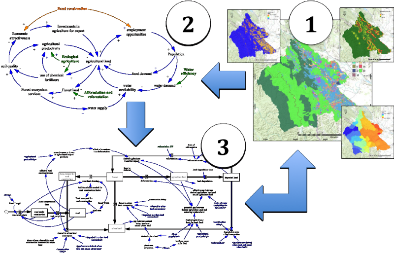
Several studies were carried out to assess the best geographical positioning for the road, and five options were taken into account before the project committee made a decision. The main criteria for the selection included construction costs and required land clearing, among others. With this information at hand, a modeling exercise was conducted to allow policymakers, land use planners and other interested stakeholder to test the multi-dimensional impact of the implementation of the project under a business as usual (BAU) and a green economy (GE) scenario, where more interventions aimed at improving sustainability in the area would be implemented. In particular, the green economy interventions simulated in this study focused on mitigating unsustainable trends resulting from deforestation for road construction, as well as from population growth driven by the construction of the road and the business opportunities it brings that affecting both urban and agriculture land expansion. Reforestation and sustainable forest management practices, as well as investments in the use of ecological agricultural practices are two examples of the interventions analysed, and results were generated in biophysical and economic terms, also including the valuation of natural capital (stocks, flows and ecosystem services).Three methodologies were used to assess the outcomes of the “Road to Dawei” project in the DTL (see Figure 2), all supported by data collection and surveys. In particular, the Integrated Model for Sustainable Land and Economic Planning (IM-SLEP) includes: InVEST, which generates spatial information and estimates natural capital and ecosystem services is used as input for estimated changes in natural capital stocks, i.e. forest land cover change, and resulting estimates of changing values in key ecosystem services (1). This information coupled with socio-economic analysis is used to create the map of the system (or Causal Loop Diagram) to identify the main drivers and impacts of land use change in the DTL region (2). System Dynamics methods require an integrated mathematical model (3) that incorporates the key drivers of change and impacts. Finally, the result of the simulations generated with the System Dynamics model can be fed back into InVEST (or any land use change modelling software, i.e. Marxan) to visualize spatially the indirect and induced social, economic and environmental impacts of road construction.

Figure 2: The main methodologies and models utilized in the study: (1) InVEST, with spatial information; (2) System Thinking, to identify key social, economic and environmental drivers of change; (3) System Dynamics, to quantify medium to longer term scenarios with a systemic and integrated approach
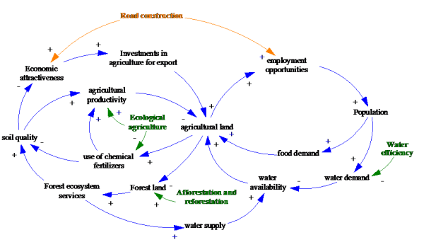
The combination of these models, and their customization to the local contexts, allowed for the simultaneous analysis of project driven impacts over the short and medium term, as well behavioral responses unfolding in the medium and longer term. It was found that these latter impacts had far larger consequences on the sustainability of the area, when compared with the immediate outcomes of road construction alone. The main dynamics identified as being the drivers of these results are presented in Figure 3, presenting a diagram that was developed with inputs from several stakeholders.

Figure 3: Causal loop diagram (CLD) representing the cause-effect relations among key indicators analysed, and the effect of green economy policy options
The results of the study indicate that it is very important to analyze the sustainability of an infrastructure project (such as through the use of ADB’s Sustainability Appraisal Framework for Transport -STAR-) as well as its additional outcomes on socio-economic development and on ecological integrity. In this respect, methodologies already exist, and coupling them (e.g. making use of scenarios and system analysis) can effectively inform decision making and support the transition to a more resilient and inclusive development.

